Your Next Adventure Awaits. Hurry up for your new expedition! Check Events

PAST EVENT

MOUNT KIPIPIRI HIKE

Dance with the Butterfly Mountain

Saturday, February 28, 2026
4:30 AM - 5:00 PM
Day hike

About This Event

Explore a solitary volcanic peak standing majestically apart from the Aberdare Range, trekking through indigenous forests, bamboo groves, and expansive moorlands to reach a summit offering spectacular panoramic views of the Great Rift Valley, Lake Naivasha, and distant mountain ranges.
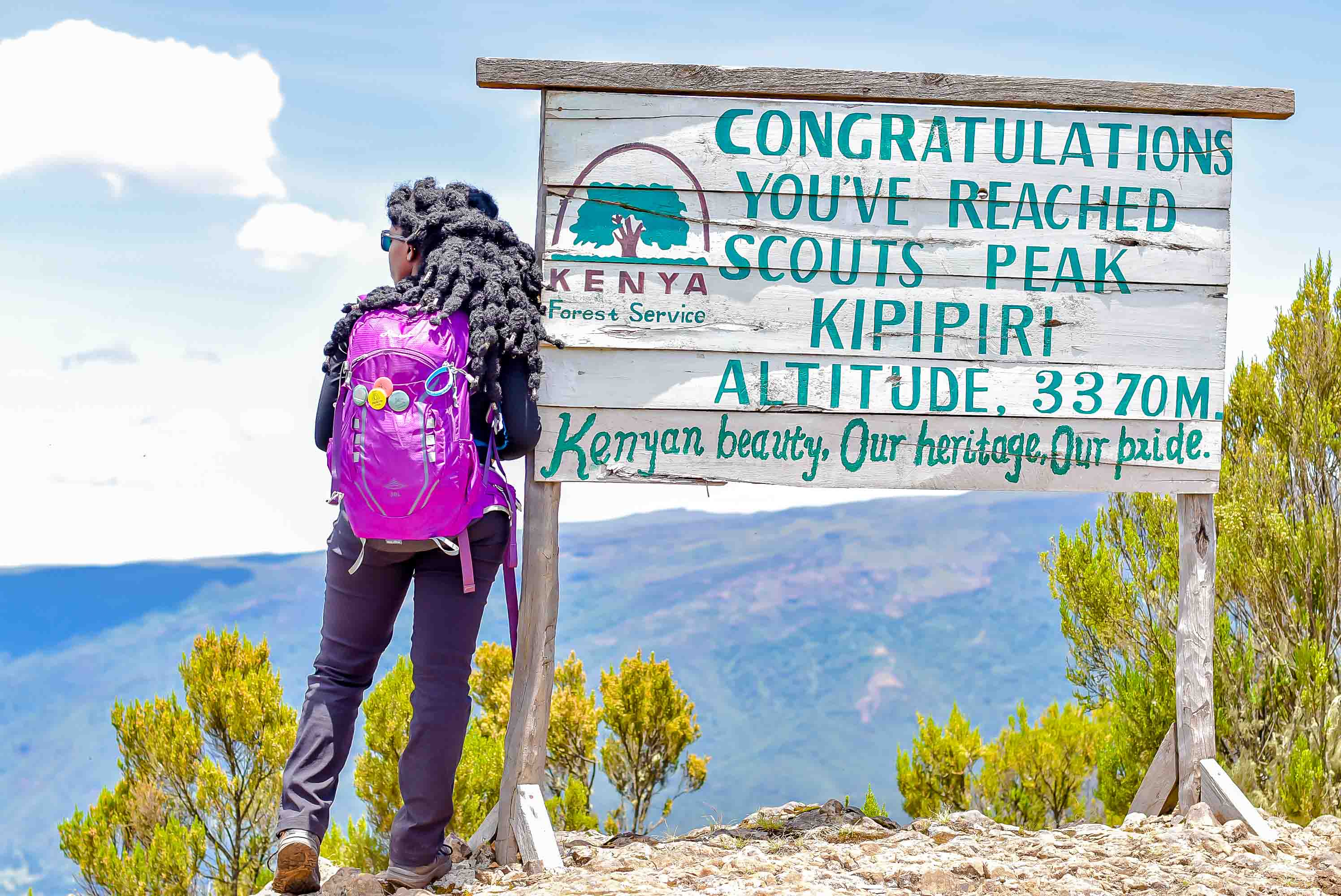
Mount Kipipiri, whose name translates to "butterfly" in Kikuyu—a poetic reference to its distinctive profile when viewed from afar—is an isolated dormant volcano rising prominently on the northwestern edge of the Aberdare ecosystem. Unlike its neighbors in the main Aberdare ridgeline, Kipipiri stands independently at 3,349m above sea level, separated by deeply carved valleys formed by streams draining its flanks. The journey begins at Geta Forest Station at approximately 2,500m elevation, immediately immersing hikers in thick indigenous forest teeming with giant ferns, mosses, and towering hardwood trees. The initial sections follow tractor tracks used for timber harvesting from lower plantations before transitioning into narrow animal trails winding through increasingly pristine wilderness. Wildlife encounters are common—colobus monkeys swing gracefully through the canopy, Sykes monkeys forage in the understory, while the forest echoes with diverse birdlife including turacos, sunbirds, and occasional glimpses of crowned eagles. As elevation increases over approximately two hours, the forest character transforms from exotic plantations to magnificent indigenous trees with dense undergrowth. Open meadows begin to appear, carpeted with expansive beds of colorful wildflowers that create stunning photo opportunities. From various vantage points, views open up to reveal the valleys below dotted with farms, houses, and the patchwork quilt of human settlement contrasting beautifully with the wild mountain terrain. 
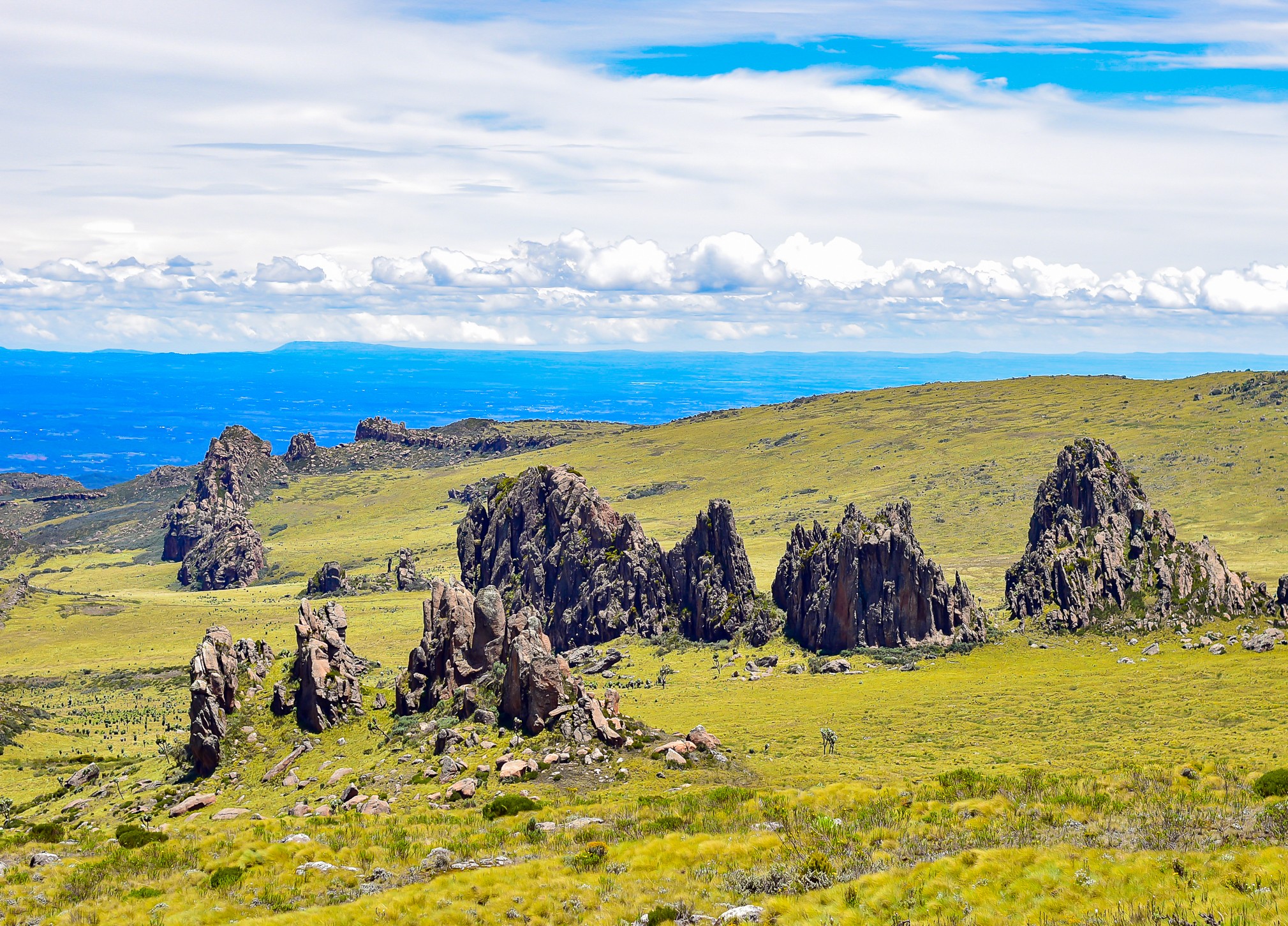
The trail continues through heath vegetation and occasional marshy sections where clumps of tussock grass provide convenient stepping stones across soggy ground. The final approach to the summit involves a steep but rewarding scramble up a conspicuously large rock formation that crowns the peak. Once atop, hikers are rewarded with breathtaking 360-degree panoramas: the shimmering waters of Lake Ol Bolosat sparkle to the north, Lake Naivasha glistens to the west about 32km away, Mount Satima and the main Aberdare Range dominate the eastern horizon, while the famous Wanjohi Valley (historically known as Happy Valley) spreads below, and the Kinangop Plateau stretches endlessly in multiple directions. The mountain lies within a protected 43 square kilometer forest reserve that forms part of the larger Aberdare National Park ecosystem, complete with electric fencing to preserve its indigenous forests. Approximately 13 elephants and numerous buffalo call this forest home, along with leopards and other elusive wildlife, making an armed ranger escort mandatory for safety. This moderately challenging hike offers excellent training for aspiring mountaineers preparing for Mount Kenya or Kilimanjaro, combining substantial elevation gain with diverse ecosystems and technical variety. The trail's relative obscurity compared to more popular Aberdare peaks means hikers often enjoy a quieter, more intimate wilderness experience. Weather conditions can change rapidly—expect cold winds, potential fog, and dramatic temperature variations as altitude increases, making proper layered clothing essential year-round.
Distance

17km

Duration

6-8 hours

Max Elevation

3370m

Elevation Gain

1050m

Event Itinerary

 4:15 a.m Assemble and board the bus at CBD opposite international House
 4:30 a.m Departure CBD opposite international House
 8:00 a.m Arrival at Starting point
 8:30 a.m Hike Starts
 2:00 p.m. Turn back time
 05:00 p.m Departure for Nairobi

What's Included

• Cozy transport to and from.
• Park entrance and guide fee.
• Access to professional workout/aerobics instructor
• Professional Photographer
• Bottled drinking water
• Community fee
• Achievement Badge
What to Wear
 Thermal base layer (long-sleeve, moisture-wicking to retain warmth)
 Fleece or insulated mid-layer (essential for the cold Aberdare temperatures)
 Heavy waterproof jacket (not just windbreaker – proper rain protection is necessary)
 Waterproof hiking pants or quick-dry hiking pants (avoid jeans completely)
 Warm hiking socks (consider wool socks for insulation in cold conditions)
 Waterproof hiking boots with strong grip (muddy, slippery, and boggy sections are expected)
 Gaiters (highly recommended to keep mud and water out of your boots)
 Warm beanie or head cover (temperatures can drop significantly at higher altitude)
 Waterproof gloves (optional but helpful in cold, windy sections)
 Poncho or additional rain cover (rain in the Aberdares can be persistent)
 Backpack rain cover (to keep your gear dry)
 Small daypack with dry bags inside (protect electronics and spare clothes)
 Extra pair of dry socks (very important in wet conditions)
 Sunscreen (UV exposure still possible even in cold weather)
 Trekking poles (strongly recommended for stability on steep, muddy terrain)
What to Carry
• National ID Card/Valid Passport
• Comfortable hiking shoes/Sports shoes. Sunglasses/sunscreen
• Snacks
• Re-usable water bottles
• Personal Medication (If applicable)
• Rain gears
• Changing Clothes after the hike

Preparation Guidelines

• Get moving with active cardio exercises like aerobics, walking, running, cycling, and swimming during the week leading up to the event.
• Designate the day before the hike for some well-deserved rest—give your body a break from intense exercises.
• Amp up your hydration game at least two days before hitting the trail.
• Make sure to prioritize a good night's sleep before the hike.
• Boost your energy reserves by upping your carbohydrate intake two days prior. If you're into intermittent fasting or on a diet, take a one-day break around the hike.
• Trim those toenails—your feet will thank you later!
• Fuel up with a hearty breakfast at least three hours before the event. This ensures your body has time to digest, providing the energy you need without making your stomach feel too full.
• Take a pre-hike bathroom break at home to minimize pit stops during your journey.
• Prepare your mindset for self-conquest. Remember, hiking is 90% mental, 10% physical prep. Once you conquer your mind, the rest is a breeze. You've got this!

Trail Information

Tractor tracks transitioning to narrow animal trails; gentle to moderate inclines with steep final approach; marshy sections; rocky summit scramble

Book This Event

Pricing Options
Category By Bus Self Drive
Kenyan & EAC Citizen KES 4,200 KES 2,800
Foreign Kenyan Residents KES 4,400 KES 3,000
Non-Resident Foreigners $45.00 $35.00
Secure payment - Free cancellation - 24/7 support
Location & Meeting Point
Mount Kipipiri, Geta Forest Station

Geta Forest Station, Geta, Kipipiri Division, Nyandarua County, Kenya, Ndunyu Njeru (registration point) / Geta (trailhead), Kenya

Meeting Point

Nairobi CBD, International House

Event Organizers
Event Details
  • Date: February 28, 2026
  • Time: 4:30 AM - 5:00 PM
  • Minimum Age: 8 years
  • Status: Completed
  • Created: Dec 22, 2025
Share This Event

You Might Also Like

MT. SATIMA VIA DRAGON TEETH (OLDOINYO LESATIMA) HIKE – ABERDARE RANGE
Moderate Intermediate
MT. SATIMA VIA DRAGON TEETH (OLDOINYO LESATIMA) HI...

Mar 28, 2026

The Lesatima (Mt. Satima) Hike is a high-altitude adventure through the rugged moorlands of the Aber...

KATHANDENI FOREST BATHING & WATERALL CHASE
Easy Beginner
KATHANDENI FOREST BATHING & WATERALL CHASE

Mar 21, 2026

The Kathandeni Forest Bathing and Waterfall Chase is a nature-focused day hike through lush indigeno...

OLDONYO EBURRU FOREST HIKE- WESTERN SUMMIT TRAIL
Moderate Beginner
OLDONYO EBURRU FOREST HIKE- WESTERN SUMMIT TRAIL

Apr 04, 2026

The Oldonyo Eburru Forest Hike – Western Summit Trail is a full-day forest hike that gradually climb...

Book This Event

Registration

Pricing Options
Category By Bus Self Drive
Kenyan & EAC Citizen KES 4,200 KES 2,800
Foreign Kenyan Residents KES 4,400 KES 3,000
Non-Resident Foreigners $45.00 $35.00
Secure payment - Free cancellation - 24/7 support
Location & Meeting Point
Mount Kipipiri, Geta Forest Station

Geta Forest Station, Geta, Kipipiri Division, Nyandarua County, Kenya, Ndunyu Njeru (registration point) / Geta (trailhead), Kenya

Meeting Point

Nairobi CBD, International House

Event Organizers
Event Details
  • Date: February 28, 2026
  • Time: 4:30 AM - 5:00 PM
  • Minimum Age: 8 years
  • Status: Completed
  • Created: Dec 22, 2025
Share This Event